

(53.1kmh, 10.99kmh av, 1068m up)
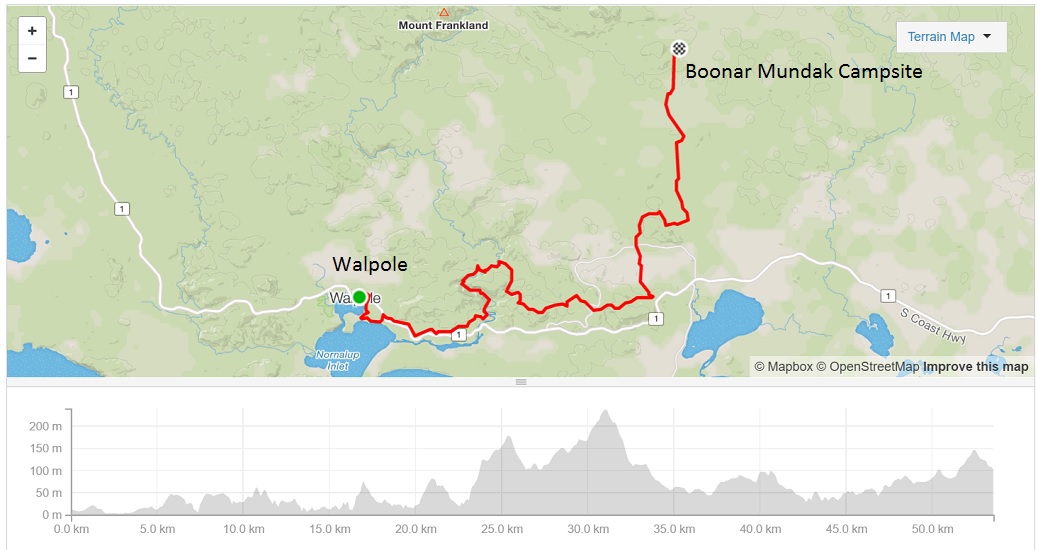
What a lovely day of riding, helped dramatically by the weather being cooperative for most of the day. After a very restful night in our Walpole four poster bed, we set off by our usual 9am, anticipating a long tough day. We returned to where we had left the trail at the Information Centre and followed a well graded track across the coastal flats for 5km to Coalmine Beach. The area was named for its low grade brown coal but never actually mined. We had great views across the inlet, and a clear reminder that we were starting our day at sea level.
The track then crossed the South Coast Highway and headed inland into the trees to begin the primary activity of the day – going uphill. We followed a fabulous single track along generously graded switchbacks through a stand of tall trees. It was a dramatic change from the coastal landscape we had been riding in just minutes earlier. The track then rejoined an old forestry road and followed a very lumpy course along the side of the Frankland River. We gained and lost elevation repeatedly, and had quickly amassed a few hundred metres of climbing despite still being only metres above sea level.
Our first stop was at Monastery Landing on the Frankland River. Contrary to our first thoughts, the area was named because of its quiet and beautiful setting, rather than any history of religious activities. It was declared a place of conservation in 1910 when it was visited by a party led by the Government Minister of Lands and Agriculture, and including the Colonial Secretary and Surveyor General, while looking for agricultural land. It would be hard to imagine a similarly high powered group of people nowadays leaving the office on such a mission, unless it was to unveil a plaque after all the hard work was done.
There was a lovely jetty on the river, and we enjoyed sitting and watching the water while having smoko. We continued our generally uphill day, with a few climbs too tough to ride. Once again, Kim came back to help push Pokey up a few of the steepest sections.
At one point, we encountered a group of about 10 hikers on a section of the trail briefly shared by the Munda Biddi and Bibbulman tracks. They were part of a commercial group taking in the best sections of the Bibbulman. They were keen to chat to us for a bit. We thought they found us inherently interesting, but quickly realised it stopped us continuing up the track to find one of their number having a “natural break”. So, we got to the usual, “We are from Atherton” bit. The leader said she’d had a lady from Atherton on the Cape to Cape trek the previous week. She was talking about a friend, Frankie, who we’d had coffee with just before leaving and were comparing notes of our upcoming WA trips. Apparently Frankie had also mentioned that friends of hers were about to ride the Munda Biddi. Small world!!
We continued upwards, riding amongst enormous Tingle trees, and crossing the Valley of the Giants Road. We met two cyclists heading north, and stopped to chat. They were towing bobs, but very interested in our set up. They knew Rod and Graham, who we had shared a shelter with on our first few days, and anticipated that they would be finishing the trail in Albany today. They teased good-naturedly about how much climbing we had left to do. We felt pretty superior. After our first few days on the trail, nothing could faze us. However we were slightly perplexed to find a road sign high in the valley for Brainy Cut Off. Did it describe a particularly ingenious diversion, or our likely state of mind if we continued on this path?

The enormous trees around us were of amazing shapes and colours, and we stopped frequently to take photos. We came across one giant that had fallen across the road, taking with several smaller trees. It took us several minutes to lug our bikes through and over the fallen branches.
From the high point of our ride, at 250 metres, we enjoyed some downhills, quickly leaving the forest and riding past green fields full of cows. We stopped for our lunch break, marveling at a day of riding without rain, just as a heavy black cloud appeared overhead. I quickly dressed in all my raingear, just as the sun started shining. Another stop for dis-robing soon followed.
The track followed an undulating course on old forestry roads, many of which were on white sand that made for slow riding. The last several kilometres to the shelter were more uphill, and we debated if this would be our biggest climbing day so far. We climbed 1068 metres, but it felt much easier than our previous 1058 metre day coming into Lake Brockman.
Booner Mundak shelter is another new and roomy building, and we had it to ourselves. We enjoyed having a bit of time to set up our gear, have a wash and prepare tea before the sun went down. After 18 days on the trail, perhaps we are starting to get the hang of this bike-packing caper.
14 September 2016